Whether aiming for the Virgin Islands or all the way to Grenada, getting to the Eastern Caribbean is well-known to be challenging because it requires going 1,400 miles east against the strong easterly trade winds (i.e., directly into it). In our case, it nearly ended our cruising life, with plenty of anguish and demands to sell the boat.
So many things I wish we had understood before heading out. The trip to the Virgin Islands is usually portrayed as having two options for sailing:
- From a latitude well above the trade winds (e.g., 25 degrees or above), head straight east from the U.S. or Bahamas until you reach 65 degree longitude, then turn south. This path requires sailing far offshore for around an 8-9 day passage. The idea is to stay north of the trade winds and sail all the way, catching a cold front with winds rotating south to west to north before bearing south and sailing with the trade winds on your port side. This is commonly known as the I-65 route.
- Hop island to island, from Bahamas to Turks & Caicos, to Dominican Republic, along south Puerto Rico, etc. This is known as the Thorny Path, or the Thornless Path according to Bruce Van Sant’s cruiser-favorite how-to book.
Among the things we learned:
- This is a gross over simplification. There are many more ways to get there, all effectively blending the two concepts.
- While Van Sant’s book is a wealth of factual and lessons-learned information that I’ve read a half dozen times, the overall theme of “thornless path” is steeped in personal opinion and at times arrogance. It assumes that lots of short day sails through carefully selected weather windows, often starting at 3:00 am, is a better “thornless” approach for a retired couple like us. Not this retired couple. It’s exhausting and waiting on those weather windows takes forever while you sit in places you don’t want to be. He acknowledges that criticism by saying you should take 3 years and not rush. Our insurance company has a different opinion about being in the hurricane zone during hurricane season.
- While you have lots of time, there is a hurricane season deadline. Thus, short hops require short stays; long hops enable long stays. While we were short hopping, and meeting other similarly-tired cruisers along the way, we saw people we knew or followed on social media biting the bullet with 3-4 day passages and then spending weeks or months enjoying their desired destination.
- For any given sea-state, sailing is far more comfortable than motoring or motor-sailing because full sails provide lift and stability. We knew this, but didn’t really internalize it until we were heading south through the Leeward Islands. Instead, we bashed straight east into wind and waves for hundreds of miles, diesel flowing and nerves fraying.
- Our personal situation was somewhat of a no-win. Brenda was diagnosed with rheumatoid arthritis around the time we first prepared to depart a few years ago. It causes fatigue and extended recovery time, making overnight passages difficult. A week of uninterrupted day sails is also not a viable alternative.
- Once you get all the way east, such as Saint Martin, it does get easier.
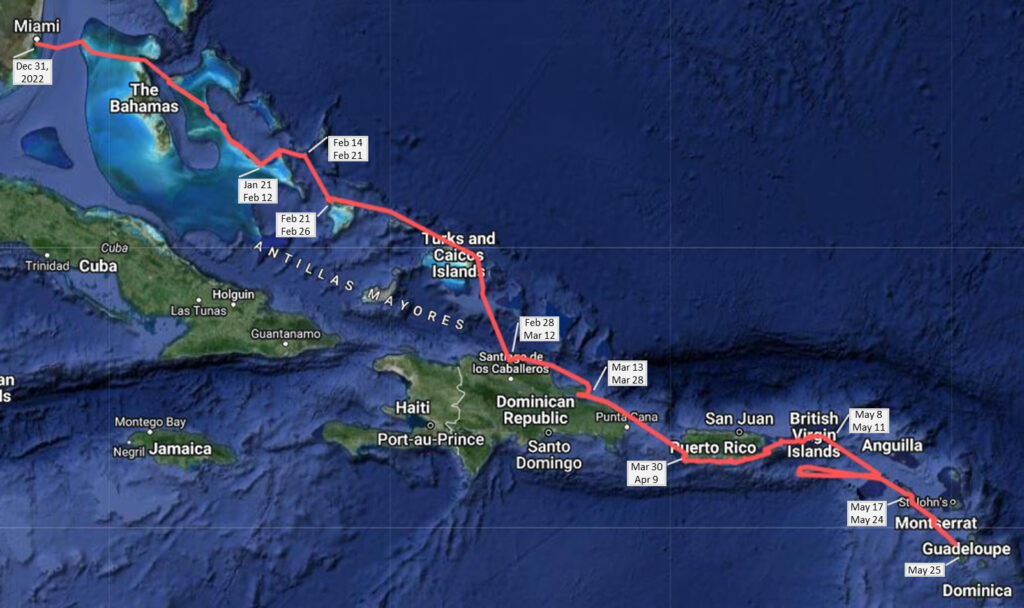
Our Route
We were not up for an 8-9 day passage far into the Atlantic and we were seduced by the Thornless Path promise, so we headed to the Bahamas with plans to island-hop our way east. We departed Miami on New Years Eve, 2022 and completed our painful easting by arriving in Guadeloupe on May 25. The majority of that five month duration was waiting on weather or day sailing to the next anchorage, not relaxing in our favorite locations. Also, our late arrival left only 5 weeks to get to Grenada, which was cut short to 4 weeks due to Tropical Storm Brett.
| Dec 17, 2022 – Dec 31, 2022 | Key Biscayne | Waited for cold north winds to end before crossing the gulf stream. Freezing inside the boat! |
| Dec 31, 2022 – Jan 5, 2023 | Bimini, Bahamas | Waited for front to pass |
| Jan 6 – Jan 9 | Clifton Bay, New Providence, Bahamas | Waited for weather window |
| Jan 9 | Shroud Cay, Bahamas | |
| Jan 10 – Jan 19 | Staniel Cay (Between the Majors), Bahamas | Waited for significant front(s) to pass |
| Jan 19 – Jan 21 | Rudder Cut Cay, Bahamas | Love this spot |
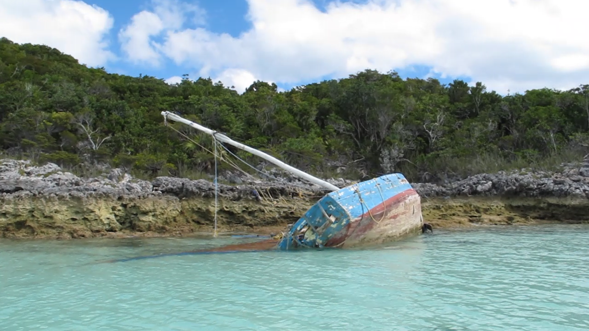
| Jan 21 – Feb 12 | Georgetown, Bahamas | Waited for multiple fronts to pass. Very windy several weeks. |
| Feb 12 – Feb 14 | Calabash Bay, Long Island, Bahamas | Set out for non-stop to Dominican Republic. Rough start, then rounding north Long Island seas were unbearable and bailed out to Calabash. While there, nearly broke bridle and anchor swivel. |
| Feb 14 – Feb 21 | Rum Cay, Bahamas | Waited for weather window. Very, very rolly. Deployed swell bridle for first time, which helped, but Brenda popped her back and was out for a few weeks. |
| Feb 21 – Feb 26 | Crooked Island, Bahamas | Waited for weather window and rested from exhausting week. Departed for a 2-night trip over TCI to DR. |
| Feb 28 – Mar 12 | Ocean World, DR | Waited for weather window. A lot of swell in this marina – 12 dock lines out. |
| Mar 13 – Mar 28 | Samana, DR | Waited for weather window to cross Mona Passage. Argued with weather router that window was a day too early but went along with the crowd. Should have listened to myself – miserable first night of bashing. |
| Mar 30 – Apr 9 | Puerto Real, Puerto Rico | Waited for weather window. Severe squalls every afternoon, often over 40 knots. Dirty mangrove water made making water difficult. |
| Apr 9 | Boqueron, PR | |
| Apr 10 | Santa Beach, PR | |
| Apr 11 – Apr 13 | Caja de Muertos, PR | Finally some good weather, blue water and white sand! |
| Apr 13 – Apr 17 | Salinas, PR | Provisioning! |
| Apr 17 | Patillas, PR | |
| Apr 18 – Apr 21 | Vieques, PR | New island, nice beach spot. |
| Apr 21 – Apr 23 | Culebra, PR | Nice exploring |
| Apr 23 – Apr 25 | Crown Bay Marina, St Thomas | Hit long fishing net enroute, starboard rudder loosened and leaking. |
| Apr 25 – May 8 | St John, USVI | Rudder leak “fixed” with 4200. Finally having some real fun enjoying St. John. |
| May 8 – May 11 | Tortola, BVI | Unplanned haul-out in BVI to drop and repair rudder. |
| May 12 – May 16 | St Croix, USVI | Planned overnight to St Kitts. Bashed all night. At sunrise, saw Saba and barely able to maintain 3 kts. Meltdown onboard led to decision to head downwind to St Croix. Turned out to be a great decision. Awesome time. |
| May 17 – May 24 | St Kitts | Left St Croix for planned overnight to St Martin. At 19:00 decided to veer toward Saba and St Kitts. Rough seas and 4 kts average speed. Almost injured trying to lower dinghy in Bassaterre’s full waves. Lost topping-lift on passage. We rested up and waited for the next weather window. |
| May 24 | Montserrat | Quick stop at this volcanic island. |
| May 25 – Jun 4 | Guadeloupe | Arrived in Guadeloupe! Finally able to enjoy East Caribbean with very limited time left before hurricane season. |
Bahamas to Dominican Republic
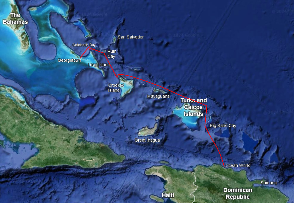
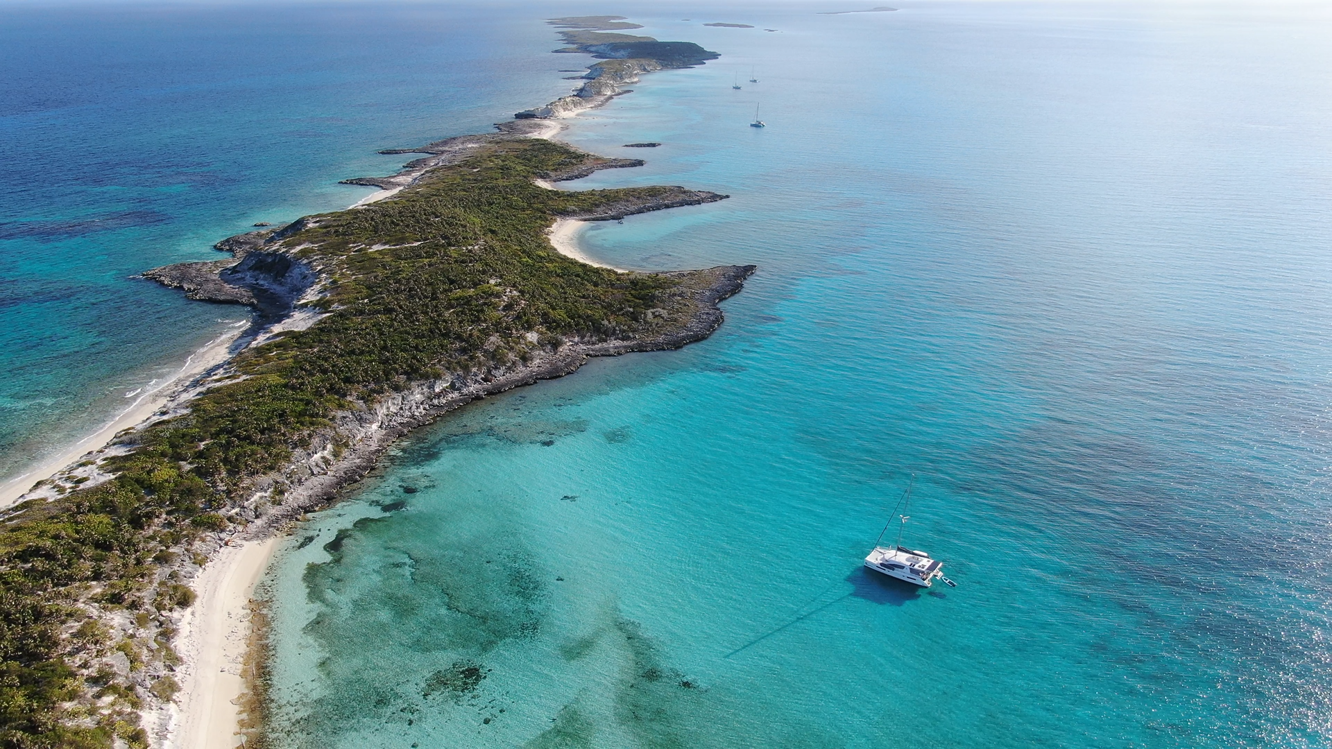
The Georgetown area (i.e., Elizabeth Harbour) is sometimes jokingly called Chicken Cove because it’s where a lot of cruisers gather at the start of the season with aspirations of continuing to the Eastern Caribbean. They attend the many meetings for passage planning discussions, but never leave. I attended several of those meetings, which were both educational and fascinating.
Nearly everyone wants to reach at least Puerto Rico or the Virgin Islands. The question is how. The two most successful routes we saw our season were:
- Sail nonstop northeast to a longitude near Mayaguana or Turks and Caicos, then sail southeast to Samana DR or Puerto Rico. This is a 3-5 day sail tacking against the trade winds.
- Motor, or sail if you’re really lucky, to Crooked Island, then through Turks and Caicos, and stop at Ocean World in Puerto Plata DR or nearby Luperon. Additional stops along the way optional. This is effectively what we did, though we did it the hard way.
The key to any plan here is to stay north as long as possible. The trade winds and current, both against you, are stronger closer to the Dominican Republic. While it may be tempting to sail to Great Inagua, the route from there onward is straight into it.
Rough Start
Our original plan was to work with our weather router, who had us lined up for a 3 night nonstop passage from Georgetown to Ocean World DR. Brenda wasn’t too sure about the projected conditions, and even our weather router said the sea state was “not insignificant”, but he had identified it as a weather window in a year where they were rare and a half dozen other boats were also going. We headed toward north Long Island at sunrise. Winds were 20-25 knots and the waves were “sporty”. We had one reef in the mainsail, but I made the mistake of not dropping to a second reef to slow the boat down and make the ride more stable. Brenda was not enjoying the experience.
We rounded Long Island mid afternoon to experience the full force of the easterly trades. Waves were now 6-9 feet high and within minutes we slammed directly into a big one. Those head-on slams are an experience – the boat shudders and almost comes to a full stop. It’s like hitting a solid wall. Emotions onboard escalated and it was clear our passage was over. I turned around and decided the nearest option was the best option, so we pulled into nearby Calabash Bay, Long Island. We found several of our fellow passage makers converging on the same spot, a mass surrender to mother nature. Ultimately, only one boat continued on and completed the passage. They were half our age, which probably helped their cause.
Surfing
We were exhausted and went to bed early. Sunrise the next day woke us up by nearly throwing us out of bed. I looked out the window to see breaking waves in the anchorage. The 20-25 knot winds had rotated during the night and were now coming from the west. The whole open ocean was heading our way and we were rotated with our backs to the beach. We had a ton of chain out and a deeply set anchor, so I wasn’t concerned about dragging toward shore. What we didn’t understand until it got worse was that the breaking waves could – and did – pick the whole boat up and throw it. Our anchoring system isn’t designed to carry a 16 ton vessel in the air. We’ve never raised anchor so fast – Brenda did an amazing job out on the bow, flying up and down, and getting soaked in the waves. We later found that our very heavy anchor swivel was bent and our anchor bridle had stretched so much that the chafe protection cover ripped off.
But now what? It wasn’t safe to exit the bay’s narrow channels through the submerged reef. That’s when we met new friends who had just completed their move and were motioning for us to head over to the north end where there was some protection against the waves. Not great, but much better. We spent another night in Calabash Bay while the winds rotated to the north and then all of us headed over to Rum Cay.
Rolly Rolly Rum
We knew from Bruce Van Sant’s book that Rum Cay had a bad reputation. It lived up to the hype. We’ve encountered this phenomenon many times. When waves encounter an island, the island’s shallows cause the waves to rotate – usually called “wrap around”. What this means in Rum Cay’s anchorage is that the waves are wrapping around the island’s southern end and heading north or north-west, while the boat is pointed towards the winds coming from the east. With the waves hitting the boat’s side instead of head-on, we were rocking side to side non-stop as each wave passed. One of our new buddy boats left for Long Island after one day of this and the other did the same after several days. We were alone.
We decided to try out Brenda’s swell bridle design, which had us hook a very long line (100′) way out on the anchor chain and pull it tight to a cleat near the back of the boat, thus forcing the boat to rotate towards the waves. It worked great! Unfortunately, Brenda gave it an extra hard pull during deployment and we both heard her back pop. She would be in pain for the next month, finding it difficult to sleep or walk.
Crooked Peace
After a full week, the winds finally let up and we had a leisurely sail down to Crooked Island. It was calm and peaceful, and our new friends were there. It was badly needed time to recuperate.
Making Miles
After almost a week of rest, a great weather window appeared in the forecast. We never expected to still be in the Bahamas at the end of February. This was finally our chance to get to the Dominican Republic. We headed out in the morning for what would be an excellent 2-night passage. Our route took us north of Mayaguana, Bahamas.
For Turks and Caicos Islands (TCI), many people go through it on the bank, possibly even stopping. We’ve been – it’s beautiful there! But they are not pet-friendly and we would be passing at night, which ruled out crossing the bank. I decided to stay north of TCI. TCI has a reputation for tight border security and social media has many stories about boats being stopped. As we approach their border around 11:00pm, I called Provo Radio and asked for permission to pass through their waters. They asked a few questions, like our crew and destination, then granted permission. No problem!
On the eastern end of TCI we turned south towards Big Sand Cay, a very tiny uninhabited piece of sand in TCI that many stop at. We had expected to arrive long after dark and stop for some sleep, but we made such good time we had arrived at 3:00pm. So, we took a nap, ate dinner, and literally sailed into the sunset.
We arrived at Ocean World the next morning around 8:00am, which is the optimal arrival time because the wind and waves pick up during the day. We made it to the Dominican Republic!
Mona
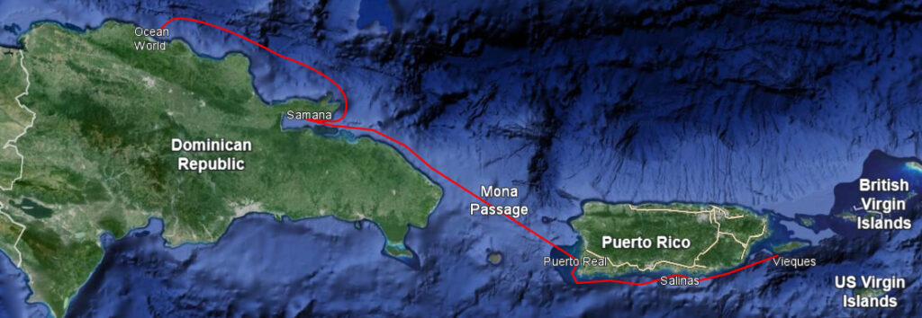
The 80 mile wide Mona Passage separates the islands of Hispaniola and Puerto Rico, and connects the Atlantic Ocean to the north with the Caribbean Sea to the south. It has a bad reputation due to variable tidal currents, sand banks extending from both coasts, and afternoon thunderstorms that flow northwest off western Puerto Rico. It is a major weather-window pit stop for boats heading east.
North DR
The Dominican Republic’s north coast is long, with only two major ports – the Luperon / Ocean World area and Samana. It becomes unsafe when there is a swell from the north and can get so bad that the Armada (DR Navy) closes the ports. We waited two weeks in Ocean World for the trade winds to relax. Throughout, there was a strong northerly swell and the ports were closed the two days before we left. Eventually, a fantastic weather window approached. We set sail late afternoon for an overnight passage to Samana. While Van Sant’s Thornless Passage book urges that you hug the coast to avoid the trade winds, we had great conditions and I opted instead to head 8 miles out to avoid the fishing traps that were littered everywhere and invisible at night. It was a beautiful passage. We were rewarded the next morning heading into Samana with humpback whales in the bay!
Samana
Samana, specifically Marina Puerto Bahía, is located in a massive bay that is open to the east. The prevailing easterly waves cause surge in the marina, but it is otherwise protected. The area is pretty, but it was yet another delay. My original hope was to arrive in the Virgin Islands early enough to stay there a month or more, but that was looking unlikely.
After two weeks of waiting and meeting others who were similarly waiting, a 3-day weather window arrived. It was not without controversy. Several of us attended our weather router’s morning online meeting. He had identified Tuesday evening as the best departure, which would have us entering the Mona Passage early the next morning. I had been studying the sea state along the DR coast, was convinced Wednesday evening was better, and said so in the meeting. I should have trusted myself. About 10 boats left Tuesday evening and bashed all night along the DR coastline. It was miserable. We all averaged 3.5 – 4 knots, which also meant we didn’t arrive at our turn into the Mona until about 11:00am and missed the wind-shadow benefit our weather router was focused on. We later heard that a couple boats left the next day and had a great passage.
Conditions steadily improved as we pushed on through the Mona, but we continued to make slow progress. At 11:00pm our port engine began to horribly shudder. We put it in neutral, turned on our underwater lights and began looking for the fishing net we assumed must be tangled in our propellers. Nothing. We tried the engine again and more banging. We looked again – nothing. When we tried the engine a second time, it was now fine and remained fine. It is a mystery to this day. We ultimately arrived in Puerto Real at sunrise instead of the evening before as forecast.
Puerto Rico
Puerto Real is a small, very protected bay surrounded by mangroves, which means the water was cloudy with silt. While it makes for great anchor holding, making drinking water there is impossible. We were stuck for 10 days of intense squalls bearing down, one after another, often exceeding 40 knots. We held great, but were amazed to see how fast some of the other boats dragged out to sea.
The trick to crossing over to Puerto Rico’s east coast is to make short early-morning hops along its southern coast. During that time, the katabatic winds flow seaward from the hills and interfere with the prevailing easterly trade winds. Once the squally weather cleared, we made quick progress. We stopped in Salinas for provisioning (Costco!) and then quickly left Puerto Rico for Vieques.
The Virgins
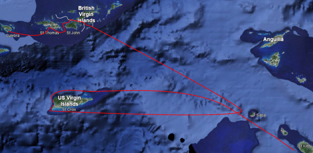
Spanish
We made brief stops at the islands of Vieques and Culebra, part of the unofficial “Spanish Virgin Islands” that are under the jurisdiction of Puerto Rico. They were nice, but we had to move on and missed a lot.
U.S.
The day we left Culebra, the winds had rotated and we were enjoying a beautiful downwind sail to St Thomas. Then suddenly we weren’t. We hit a large fishing net and were dragging three buoys on our starboard rudder. It eventually freed itself, but we noticed a new noise while steering that wasn’t there before. We traced it back from the wheel to the chain to the cables and ultimately to the engine compartment, where we saw the rudder post was loose with a small leak. I locked the wheel in a straight position and proceeded to steer by alternating the throttles of our two engines. A few frantic phone calls later we had a marina booked where we could be safe and plan next-steps.
The best haul-out for repairs was in the British Virgin Islands. We hadn’t planned on going there. After temporarily stopping the leak with a sealant (4200), we decided to enjoy St John for a couple weeks on our way to the BVI. St John was where I had wanted to arrive. I had been there decades before and remembered it as a tropical paradise. While we enjoyed it, we both had a disappointed reaction. The reefs were mostly dead and it was more dry brush than tropical, but the beaches and water were great and rest was badly needed.
British
This was not a site-seeing visit. We went straight to Nanny Cay Marina for repairs and were ready to go after a few days.
U.S. Again?
We were getting late into the season, so we opted to head straight from BVI to St Kitts instead of the more typical route via St Martin. We left BVI mid-morning on yet another diesel-flowing bash fest. It was a long, rough night. By sunrise, we could see Saba but were barely able to maintain 3 knots speed. At that rate, we would never reach St Kitts before sunset and Saba and its neighbor Sint Eustatius were not viable bad weather anchorages. The mood on the boat reached a new low. What now? Downwind! A hard right turn and we were off to St Croix.
St Croix was one of our favorite stops in the whole Caribbean, specifically the Frederiksted Pier on St Croix’ west coast. We went scuba diving on the pier every day, amazed by the diversity we found there.
Leeward Islands
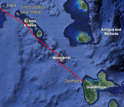
Unfortunately, time was running out and we had to leave St Croix. One route that’s not on anyone’s Thorny Path list is St Croix to St Kitts. It’s direct east to Saba and then southeast to St Kitts. So of course we took that! Actually, we had a tentative Plan A to St Martin and Plan B to St Kitts, aiming mostly east until we had to tact and commit to a destination. It was a bash fest either way and that night we veered toward Saba and St Kitts. It was rough and the next morning we found our topping lift had broken, which is the line that holds up the end of the boom. Fortunately I had recently bought a replacement and was able to make the repair in St Kitts.
St Kitts Customs office is in the capital, Basseterre. Beware! The waves come rolling in as if you were out at sea. We anchored close to the dock and nearly suffered severe injuries trying to lower the dinghy into the surf. I hurried to check into the country and then we raised anchor as fast as we could to get out of there. White House Bay further south had much better protection and there we waited for the next weather window.
The final leg of our “easting” was heading southeast down the Leeward Islands to Guadeloupe. This, fortunately, was pretty uneventful.
A brisk 9-hour motoring into 20 knots brought us to Rendevous Bay, Montserrat. No sailing for us! Compared to our last few passages it was down right pleasant. We were staying for just one night, so we flew our quarantine flag and didn’t check-in. A young member of the Montserrat Navy stopped by, asked a few questions, and wished us a good night. Very pleasant stop.
Our final leg to Guadeloupe was another 7 hours of uneventful motoring. Perhaps we were just getting used to it. Our journey changed after this, with some epic sailing down the Windward Islands.
